
Our destination was the Tonga Ridge trail, with the expectation that we'd end up on Mt. Sawyer and be back home by 6pm. This was the first time either of us had been to this trail - and the first time we had hiked in this 'neighborhood'.

The road to the trailhead is rather long... about 10 miles or so of gravel roads. Fortunately for my Camry, the road is in excellent condition. Very minor washboarding on a couple of the corners and absolutely zero potholes. The only road hazzard we encountered (but avoided) were two huge holes in the road about a mile from the trail head. These don't appear to be potholes. They appear to be sinkholes: small but deep. Just the right size to drop one of your tires into and break an axle or a tie rod - or maybe bend a rim, pop a tire and destory your alignment. Seriously - if you hit these it's going to cost you big time for towing and repairs. It's easy to drive around them (without even slowing down) but the price is high if you don't see them in time to avoid them.

Upon our safe arrival at the trailhead (Northwest Forest Pass is required for parking) there was only one other vehicle in the small lot (and just wait until you find out who's vehicle it was!). We expected more on such a beautiful August Saturday.
Also at the trail head parking lot we found bugs. More than plenty of them. "Keep Moving" became the name of the game. Mostly mosquitos, but also some small flies and a few bees.

This trail enters the Alpine Lakes Wilderness, so be sure to grab a permit at the trail head, fill it out, stick the bottom stub in the drop box and attach the other half to your pack. It's free... unless you're lazy and don't do it, then end up with a ticket.

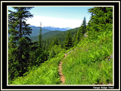
The trail begins on the crest of a wooded ridge. No views to speak of, but it's obviously a ridge since the ground slopes away rather noticably on both sides of the trail.
Just like the Topo map shows, eventually the ridge continues upward, but the trail levels out and sidehills on the south side of the ridge.

Concerned that maybe we missed a boot path that would keep us on the ridge, we left the trail at a pink ribbon, trying hard to follow a non-existent trail. Not quite what we signed up for, so we returned to the trail and continued onward.
Eventually the trail finds patches of clearing which offers some views to the south. We also found another boot path that provided a glimpse to the peaks on the north side of the ridge. Still, no boot path to continue up Tonga Ridge. Why would they call this Tonga Ridge trail if we were just going to be side-hilling it the whole time? We were concerned that this would amount to the highlight of the hike. Our concerns were unwarranted... the trail does get better - as the pics indicate.

At about the 1.8 mile mark (per gps) we came across a couple on their way back to the trail head.
We both inquired with them and they inquired with us: Where is the boot path to Sawyer Mountain? All four of us were a bit flummoxed that we weren't on a ridge, enjoying sweeping views. Sure, we were on the trail, and the trail was going right where the topo maps indicate it should go... but why on earth isn't this trail on the top of Tonga Ridge?
The couple we met had brought along some beta from the internet which indicated the boot path to Sawyer Mtn is near the invisible tarn. they went to the invisible tarn but couldn't locate the boot path... had given up and turned around.

We invited them to come along with us. Another couple sets of eyes might help solve the mystery. It's a popular trail, so the boot path should be pretty obvious... wouldn't you think?
Shortly thereafter we arrived at the invisible tarn. There were a number of boot paths, but none seemed to go beyond the tarn flats. We could see Sawyer up above the tarn flats.

By the way... near the middle of the tarn flats there seems to be a big hole. Big. Hole. Well, about a 2 foot deep divot. Maybe the tarns drained down into the ground here? Maybe it's just the remnanats of someone's old fire pit? Should have snapped a few pictures of it, but didn't.

There were still a few potential bootpath leads to investigate at the flats, but we decided to continue on the trail for a litle ways first... just in case it was just ahead of us.

Viola! Just a ways beyond the tarns, after entering back into the trees, a boot path is marked with a pink flag and immediately begins ascending Sawyer Mountain!
Up we went.
You can clearly see on the topo profile how the elevation gain on this trail is all due to Mt. Sawyer.
During our ascent we conversed with our new friends about where we like to hike and other important topics. Through the course of this conversation we started talking about nwhikers.net. Elvis, meet Realityguy. Realityguy, meet Elvis.
Pleased to meet you!
Discussion eventually turned to the topic of goats. Goats led to a discussion about the hiker that was killed by the goat in the Olympics in October 2010. Realityguy then informed us that he is the hiker that first came across the gruesome scene. That spurred more interesting conversations, as you can imagine.

Eventually, Realityguy & his spouse continued upward while we meandered our way up a little more slowly. We finally passed by them on a little snowfield just below the summit, where they had stopped for lunch in the shade.

The snow covers a very small area... maybe 50 feet at the most. Stay to the left and you dont' need to worry about sliding down the backside of the mountain. No equipment needed... don't give up, you are so close!

We quickly made our way to the top, took lots of pictures, unintentionally located a geocache, ate lunch and took more pictures. Then applied bug spray.
Fantastic views from up there! This is a great hike if you are looking for an easy summit... and the weather is nice.
We could tell that the Puget Sound was still locked in a marine layer while we were basking in cloudless blue skies and sunshine.
Realityguy & his wife joined us a short while later and then they headed down a few minutes before we did.

As we descended, there was another group on their way up - already at the snowfield. We encountered a second group as we neared the bottom of the boot path and then a few more groups between there and the trail head.
The hike out was pretty quiet and uneventful as we contemplated goat attacks and why the heck isn't this trail on the top of Tonga Ridge?

The ride back to Monroe was uneventful and I was home in just enough time to be at the Skagit County Fair for the 4H awards.
Thanks Steve for coming along - this was a perfect choice for today.
Thanks Realityguy & wife for being awesome (and interesting) trail partners too! Glad we crossed paths.

6.1 miles round trip.
1,330 feet of elevation gain.
If you want to see some of the above pics without all the fancy photoshop fluff, they are posted 'au natural' over on nwhikers.net in the Tonga Ridge / Sawyer trip report.
Happy Trails!
~E
Next hike has been rescheduled for September 5, 2011 (Labor Day). Best to check the 2011 Hiking Calendar for updates in case something changes.

No comments:
Post a Comment