Tuesday, November 29, 2011

Chuckanut's Huckleberry Point 11-21-2011

This was the second of two 'hikes' for the day.
After a foiled attempt to drive to the Samish Overlook, I found myself visiting Clayton Beach for a short while (Trip #161) before driving north on Chuckanut to the North Chuckanut Mtn Trail Head parking lot for Trip #162.

On this occasion, the parking lot was completely empty, except for a Border Patrol SUV; its engine running and an officer in the driver seat. A simple nod of the head between us sufficed for a greeting. It was my assumption that he was just hiding out on a lunch break, but that probably wasn't an accurate conclusion. Regardless, I was glad he was there as this is known to be a popular vehicle-prowl area. Surely he wasn't there for that reason, but it serves that purpose for me.


Started hiking, still unsure of my real destination.

The trail signage at this point wasn't too helpful in pointing me in the right direction since it only shows distances, not directions. It did help me to cross off a few potential destinations due to the length.

At this point it seemed best just to wander around toward the Pine/Cedar Lakes/Raptor Ridge area; just to say I've done the entire segment from the North Chuckanut parking lot to the Raptor Ridge intersection (which I've been via the Pine/Lakes trail head).

My route stayed to the north of California Street, and I stayed 'high' instead of dropping into the Chuckanut Creek/Arroyo Canyon area. It's a neat area, but one I've been through on numerous occasions via hiking, running and biking. That way just leads to the road, then the interurban trail and then to Fairhaven Parkway. No thanks.

Was pleasantly surprised to see signs for Chuckanut Falls... wasn't on my radar screen until now - a nice potential for a surprise gem. Decided to follow the signs and leave Lost Lake to be found on a different day.


The trail to the falls contained some slick muddy spots on a grade steep enough that a few footsteps were of the step-and-slide variety, but the trail is well established and obvious to follow.


At the time of my visit, the falls weren't all that impressive, but it was on par with the rest of the day I guess. Since my visit, I've found a few pictures online that show the falls with a higher volume of water which only adds to the attraction.  One such picture is posted on Aaron's Waterfall World website.

After a few photos it was time to return to the main trail and continue on the original path.

Side note: Strong winds have been blowing around Skagit/Whatcom county for the day before this hike and also the day of this hike. Fortunately, at the time of my visit to this trail the winds were pretty calm - almost non-existent (although they were simultaneously howling at other Chuckanut locations). Hiking in the woods during high winds can be a risky endeavor. Branches can and do fall during wind storms. Many are small - but still capable of causing injury. Others are larger, or even huge, and can cause significant damage - even death. At one of the junctions to Chuckanut Falls, I came across this huge branch that had fallen and impaled itself at least four inches into the hard packed (but wet) dirt. Hard enough that it was standing up straight... more than six feet high.

Here's the picture... imagine what kind of damage that could do to a body... a shoulder... a head... a foot. Be careful and be aware of these risks whenever the winds pick up.


End Side Note.

After plodding along the Hemlock trail some more, there came another unexpected option noted on a trail sign: Huckleberry Point.


Never heard of it before. since it's only 0.4miles, and the trail appears to go 'up', there's no way to ignore it (yet).

I raced a slug. Yes, I did win, but the slug got the photo finish.


Like the Chuckanut Falls spur trail, this one is easy to follow, but pretty uneventful. The route will lead you up to a wooded flat spot. With a bench. Technically, there is a view. Near as I could tell, it's a view of some treed ridges with houses. Probably looking over Lk. Padden and Lk. Whatcom to the big power lines in the distance.

I call this 'the pondering place' because I couldn't help but ponder why this was deemed worthy of a 0.4mile trail and a bench. Pretty sure even the slug turned around when I told him what was up there.


Upon completion of the 'Pondering' phase, it was time to return to the trail head. An uneventful trek (but it seemed longer on the way out, even though there wasn't a side trip to the falls). Wished there was an Alpine Coaster nearby.

Border Patrol officer was still sitting in the parking lot. I told him thanks for watching my car. Not sure why or who decided it would be useful for him to sit there for two hours when there didn't seem to be any activity in the area. Whatever... no one broke into my car so, Thumbs Up!

Didn't get rained on while hiking at all. Started to sprinkle as I put the pack in the car.

Loaded up, went home & washed the dirt off "Puddles" at the car wash on the way.
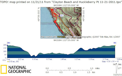
Route Map:


Happy Trails!

~E

Monday, November 28, 2011

Itinerary for 11-29-2011

Another day off of work... oh the joys of 'maximum PTO carryover', 'floating holidays' and 'unpaid furloughs'. Combine that with the fact that I've already exceeded the monthly gas budget and you end up with another day of solo dumpster dive hiking.

In this case, dumpster dive hiking doesn't mean that a trail is lame or a waste of time, it just means that it's so close to home that it generally wouldn't warrant a full day of attention on one of my 'regular' hiking days.

Since I didn't have a whole lot of hope that I'd actually manage to get the day off, there hasn't been any pre-planning done for the day. A quick check of the weather forecast shows potential rain in Skagit & Whatcom counties... right where my dumpster dive hikes are located. Go figure that the weather looks potentially fantastic for Wed through next Tuesday... but I'll be in the office on those days.

Grumble, Grumble... that's a lot of complaining about stuff that is out of my control.

In my world, it's a day off and I'm excited to make the best I can of the weather conditions and the destinations. It WILL be fun. I'll take pictures and post them online for you to ponder (probably you're already pondering my sanity).

Although the plan may change based on the weather, or instinct, the current plan is to start off the morning with a hike around Hoypus Hill on Whidbey Island (just south of Goose Rock, where you can catch the boat tours under the Deception Pass bridge) and then end the day with a quick Chuckanut hike to Lizard Lake from the Upper Blanchard Trailhead via the Incline Trail; maybe I'll continue on to Lily Lake and North Butte (unlikely).

The idea for Hoypus Hill came from reviewing one of Craig Romano's hiking guide books. That's a funny story for another day - but until then, you can visit Craig's facebook page. He's currently offering his books for $15 each plus $3 for shipping... and further discounts if you want more than one title!

Well, better go dig up some maps, tinker with the GPS, recharge the batteries and figure out where the rain gear is at.

Happy trails!

~E

PS: Two trip reports are in the works (Huckleberry Point and Badger Mountain)... hopefully they'll be online before the end of the week. Thanks for your patience!

Wednesday, November 23, 2011

Clayton Beach 11-21-2011

After living in the Chuckanut area for 23 years, I finally made a visit to Clayton Beach.

Clayton Beach is a popular destination for locals. It offers access to the waters of Puget Sound, a rope swing, nice scenery (in good weather) and some train tracks.

The weather was less than idea for a visit to Clayton Beach. Stormy weather wasn't a surprise because it's been forecasted on the news for days, but what I hadn't considered were the tide tables.

My visit seems to have been at high tide. So, there were some nice solid and scenic rock slabs to sit on and hang out, but as far as an actual beach to get up close and personal with the water didn't seem to exist.

Maybe the 'beach' part of Clayton Beach is under water at high tide.

Parking for Clayton Beach is in a fair sized parking lot off Chuckanut Drive, about a mile south of Larrabee State Park. At the present time, a Washington Discover Pass is required for parking ($10/day or $30/year). I believe you are able to self-purchase a day pass at the parking lot (cash into envelope into drop box, no credit cards or electronic payments).

There are a few parking spots along the side of Chuckanut Drive itself, but those too are marked as 'Discover Pass Required'.


The hike from the parking lot down to Clayton Beach is less than a mile and is probably less than a 200 feet elevation change, but parts of the trail are indeed steep, potentially muddy and contain many tree roots. Please use caution.


The rope swing was a pleasant surprise, but as with most rope swings, it's not an official attraction and no one really knows who put it there, how long it's been there or whether it is safe to use or not. Use it only at your own risk - they can be dangerous and this one is no exception.

Will probably have to swing by here again in the summer at low tide to see what all the hoopla is about. For those of us that live year... Clayton Beach offers a lot of scenery that is also available at other locations - such as Larrabee Park which seems to offer better beach access and plenty of amenities.


GPS/Topo Image: I went straight down to the beach (via the rope swing), then wandered south along the train tracks (RR ties are gross and slippery), then wandered North to the Larrabee Park Entrance before returning to the car via the interurban trail.


Once back at the car, I resumed a drive to the north for a hike to Huckleberry Point (trip report coming in the next week or so).

Happy Trails!

~E

Sunday, November 20, 2011

Lack of an Itinerary for 11-21-2011

Itinerary for 11-21-2011

Another solo week-day of hiking. Well, maybe a half day of hiking after Alexia gets dropped off at school at 9am. That's a pretty late start when the sun sets so early.

Weather is sketchy: cold, rain, sun, snow at higher elevations, and wind advisories.

Where to go? Dunno. Too many unmotivating choices to choose from.

Snowshoeing in fresh snow from the lower Mt. Baker lodge to Razor Hone Knob (again, now with more-leaky boots)?
Chuckanut's Incline Trail to Lily and Lizard Lakes?
Try to find the Sumas Mtn Overlook?
Shadow Of The Sentinels trail by Baker Lake (so darn short)?
Wander the Logging Roads in the Alger Alps?
Diablo Lake Trail to Ross Dam (too far away for such a late start)?
Explore FS Rd 38 toward Elbow Lake?

Just can't decide... but I do know that I need to get back into a regular running schedule. There's a lot more motivation to go somewhere difficult when you believe that you have the physical capabilities to actually reach that destination.

Send me your ideas, suggestions or even invitations. Chances are that I'll be in this same boat again on Tuesday.

Happy Trails!

~E

These posts were made pretty close together... you might have missed the trip report for my outing on the Iron Goat Trail on Nov. 13, 2011. Read all about it right here.

Iron Goat Trail, West of Windy Point 11-13-2011

Just as the first real round of winter snow began a constant and threatening descent onto the Cascade Mountains, my feet took me to the Iron Goat Trail for a little exploring along the old rail routes from the early 1900's.

The snow wasn't too deep yet - only about four inches in the deepest locations. However, this is just temporary as this Iron Goat Rail Route crosses numerous avalanche paths and it is not a wise place to be once the snow really begins accumulating on the mountains high above you.

One such avalanche occurred just a few miles to the east, at the location of a small railroad town named Wellington. The avalanche wiped out two passenger trains, pushing them down the mountain, with few survivors. This remains the most deadly avalanche disaster in the lower 48 states.

As mentioned earlier, this hike occurred just as the snowfall began accumulating - before any avalanche conditions could build up.

It is my recommendation that you not visit this trail until late in the summer of 2012. In the meantime, read the fantastic guide book published by VOW and the Mountaineers. It's currently available here.

There is a whole lot of really great (historical) stuff to see here, in addition to the scenery. It's one of my favorite destinations when I'm looking for something low-key but always interesting.

This hike is great when the weather is wet or the sun isn't sunny.

The trail head is easy to access, right off Hwy 2 before you start gaining elevation up to the pass. There are actually three trailheads: Wellington (eastern trail head), Martin Creek (western trail head) and Scenic (the middle trail head with it's own Caboose).


This particular hike started at the Scenic trail head and immediately gained about 700 feet of elevation via the cross-over trail to Windy Point Tunnel.


Once at Windy Point, a left turn starts you off to the west, toward the Martin Creek trail head. This is also where you can venture a short ways into the Windy Point tunnel. Hold onto your hat - I almost had to chase mine into the dark.


Heading West, the trail will follow the old rail road route along its upper grade, often next to the inside wall of long-gone snow sheds which would aid in keeping avalanche debris off the tracks.


There are other neat things to see, including wash outs that left a retaining wall standing by its lonesome, with a 6 foot tall hole in the bottom of it, or tunnels that are being gradually filled in by Mother Nature herself.


Look closely... there is a mile marker in the center of the picture.


After about 2.5 miles of hiking on the upper grade, a trail junction with the Cortea Connector trail makes for a good shortcut down to the lower grade. Taking this shortcut means you won't go by the Martin Creek Trail head... but it will pop you out near the lower grade's twin tunnels, a new wooden bridge and finally back to the parking lot for a 6 mile loop.


Here is a short video and a GPS Waypoints image.


Feel free to post comments or ask questions.

Happy Hiking!

~E


Links to my other Iron Goat Trip Reports:
Wellington To Windy Point Tunnel (Aug. 8, 2009)
Exploring Windy Point (Aug. 12, 2007)

Saturday, November 12, 2011

Itinerary for 11-13-2011 v2

Yep, looks like this may be one of the wettest hiking days in years. Possibly the wettest since Rob & I visited the Iron Horse trail in 2005 - it was so wet back then that my pants actually were producing bubbles from residual laundry detergent.

Since it appears that I'll be solo for the day, the itinerary is pretty much wide open and subject to change.

At this point in time, I'm considering heading east on Hwy 2 toward Steven's Pass. The intention is to hike at least a portion of the Iron Goat trail (staying west of the Windy Point Tunnel) and then probably make a visit to the Index Town Wall.

The Iron Goat section will probably start at the Interpretive Center at Scenic (if accessible) with a hike up the new switchbacks to the tunnel and then just meander westward from there. Probably too far and too little daylight to do the whole loop, so it will be an out-and-back.

If I can't get to that trailhead, I'll try go get to the other one that is further west (although the name of it currently escapes me).

Directions to the Index Town Wall can be found on Craig Romano's website since he posted it as the Hike of The Week.

Backup plans for those destinations would include the typical defaults such as Wallace Falls State Park, Heybrook Lookout, Lake Serene / Bridal Veil Falls.

Then again, maybe I'll just stay warm and dry at the Tulalip Casino playing Bingo.

Whatever the day holds, I should be in cell phone contact by dark.

Happy Trails!

~E

PS: The Camry has moved on to enjoy a new well deserving family and so it will be the first hike for the yet-to-be-nicknamed trail car.

Post a comment if you'd like to offer up some suggestions.

I'll get things rolling with a couple possibilities:

} Puddles
} Silver Bullet
} Precious 2
} Choc L8 Thunda!

Your turn....

Friday, November 11, 2011

Itinerary for 11-13-11 (v1)

Looking a bit wet.


Get to break in the new trail car this Sunday... little nervous about that.

Wonder if I can rent the Camry for the day from the new owner?

:)

If you've got a good set of rain gear and you are interested in a potentially wet day of hiking on sunday, please let me know. I'm in need of a good destination, some entertainment and maybe somebody who wants to drive. There, I said it.

~E

Saturday, November 5, 2011

November Countdown

Next hike date is Sunday, November 13th.

Usual issues with questionable weather and currently no known hiking buddies for the day.

Snow is already on the scene... in fact, you can see it in the foothills.

Feeling a little bummed about how few 'new destinations' were crossed off my list this year - seems like they were mostly of the dumpster dive variety.

Destination for Sunday is still tbd. Considering an early winter trip to Railroad Grade/Park Butte or contemplating a trek up to Hannegan Pass before the avalanche risk starts to be a concern.

If you are interested in hiking on Sunday the 13th, please let me know.

~E