Saturday, September 29, 2012

Gothic Basin and Foggy Lake 09-16-2012

Gothic Basin and Foggy Lake are often listed as a favorite hike for those who spend a lot of time exploring the Mountain Loop Highway.

The scenery must play a huge role in the decision to list this as a favorite hike because let me tell you... the trail is not kind.  Sure, it tricks you into thinking "Oh, I am so ready for this hike.  One mile in and I'm not even sweating... just a few more miles to go and I'm golden!".

A sweet stream crossing at an opening in the trees just adds to your ego.  Looking up toward the sky at the cliffs while crossing the stream gives you the feeling that "Yes, I am invincible and honestly, it that cliff is the top of this hike then maybe I'll head up Del Campo peak after a swim in the lake."

It's at that point when your nose bumps into the trail because that's how steep it gets after that  innocent creek crossing.

Maybe it isn't quite nose-bumping steep (but have you seen my nose?), but it will absolutely get your attention.  For a long time.

My advice:  do this trail when the weather is your definition of "Perfect" AND after you've done a lot of quality aerobic training on the stairmaster (or equivalent exercise regime).  If the views aren't available go do a training hike on Mailbox Peak (or Mt. Dickerman, much closer) and come back a different day.

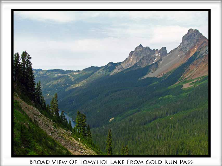
I didn't do any hiking in any part of this picture.  The trail is right behind me and this is where I turned around.  Foggy Lake is almost entirely melted out and a summit of Del Campo Peak will have to wait for some other day (but actually it isn't even on my list of things to do, so no promises on that).

Now, let me share a little more about the trek from the parking lot to the above 'parting shot'.

Trail head parking for the Gothic Basin/Foggy Lake trail is available at Barlow Pass along the Mountain Loop Highway (MLH).  For those not familiar with the area, the MLH is east of I-5 and connects Granite Falls in Snohomish County and Darrington in Skagit County.  Barlow Pass is about halfway between Granite Falls and Darrington.

The basic trail route is about 9.75 miles (round trip) and 3,200 feet of elevation gain between the parking lot and Foggy Lake.

From the parking lot, cross the MLH and proceed down the gated road toward the old mining town of Monte Cristo.

While loading my backpack at the parking lot, I met a couple other hikers who were also about to make a first visit to Gothic Basin; Doug & Diane.  They were both from out of state, relocated here for work (separately, didn't know each other, one from Boeing/Air Force and one with Coordinated Healthcare) and were part of a 'meetup.com' outing.  Their Leader, Ruth, was doing warm up stretches.  Doug & I started chatting and began the hike together.

This road will take you down to the river after passing through a recent landslide.  Warning signs indicate the landslide continues to be 'active' so use caution.  There appears to be a detour set up to allow hikers the option to hike up the hillside to cross the slope above the landslide instead of just going straight across it.

Not sure if that is more or less dangerous if the slide is reportedly active.  Again, use caution and exercise good judgement and proceed at your own risk.

Shortly thereafter is an outhouse (your last one on this trail) and another trail junction.  Straight ahead will take you to a log crossing of the river and the route to Monte Cristo and is NOT the way to go.  Instead, follow the trail to the right.  This junction is probably signed as Weden Creek/Gothic Basin.  The Weden Creek Trail will naturally become the Gothic Basin Trail after you cross Weden Creek.

Enjoy this section of trail as it contains the last bit of 'flat' you'll see for quite a while.  Of course, this section doesn't really have too many flat sections, it's more of a rolling up and down, but they are just minor bumps, relatively speaking.

Shortly thereafter you'll cross Weden Creek.  This is a good chance to consume some calories, drink some water and possibly remove a layer or two of clothing now that you are warmed up and about to break a sweat.

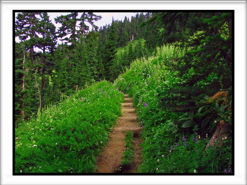
The scenery will now focus primarily on the ascending trail.  Pray a few thank-you Amen's to God that the trail provides plenty of shade.

Keep your eyes peeled for remnants of mining operations from decades ago.  Here is a pipe that is sticking out of the trail.  A few feet further up the trail  more sections of the unburied pipe are exposed.
 While I can't tell you any other cool or interesting info about this particular pipe, I can tell you that just a short ways beyond it you'll break out of the trees to enjoy some views, sunshine (no sun?  why are you on this trail?) and possibly another calorie/carb/water break.

Don't stop at the first views, proceed another 30 yards around the next corner to this view and water crossing.  THIS is a nice break spot.
 I took a long (needed) break, taking lots of pictures to distract myself from the muscle spasms.


At this point I continued onward while Doug, Diane & Ruth extended their break for a while longer.  We would cross paths again later (twice).  Since I needed to be home by 5:00pm to let the dogs out it was going to be necessary to pick up the pace a bit.

The trail incline lets up somewhat as you contour around a ridge and valley or two before coming to this interesting waterfall.  I'm sure it could be a bit intimidating earlier in the season when it's being fueled by rapid snowmelt.  It makes a nice spot for lunch or a break too.  Take your time here (it's pretty); the trail will be steep once again as soon as you move along.  My three trail buddies arrived just as I was ready to move along.

 Here is an 'abstract' photo showing the reflection of the waterfall in a little sheltered pool of the creek:
 Here is where the creek continues its journey into another waterfall.  It's interesting that we have no idea how big or little this waterfall is.  It's also interesting that I didn't venture over there to see if I could safely peer over the edge and see.
 At this point the camera was put away so I could focus on the unpredictable trail obstacles:  roots, rocks, boulders, logs and 'vertical'.  There are indeed places along the trail where you need to use your hands to steady yourself or assist with a super-sized step up.  Right about now you are cursing that first easy flat mile because you know it's forced you to gain all this elevation in a shorter distance than any not-insane person would ever want to do.

Eventually there is a point where you cross over a little pass which opens up a whole brand new set of views.

This is the first little tarn.  Foggy Lake?  Not there yet... more elevation to come.
 From this little tarn (above), follow the trail to the right where it will ascend another slope or two (to the right, out of the picture).  The two photos below are looking back from where I came from (hiked in from the left of the water).

Other hikers climbed to a high point on the other side of the tarn (right side of the above picture).

At this point it was 1:30pm.  My turn around time.  Big dilemna.  I never miss a turn around time.  However, conditions were so perfect and it was such an effort to get here and Foggy Lake was virtually within reach... so I decided that I'd continue on to 1:45pm and then turn back, regardless of location.

The very last section to Foggy Lake had a very short snowy section which you can circumvent if you want to, and then a flat section through an interesting 8 foot deep 'trough' in a rock (no pictures, too dang exhausted and running out of time).

Luckily, I reached Foggy Lake at exactly 1:45pm.  Out came the camera, snapped about 10 pictures and then turned around to start the descent.  No time for a break or any of that nonsense.    It would have been nice to have extra time for exploring the area, but that will have to wait for a day when I have more time and apparently more pre-hike training.


Leg cramps started almost immediately upon reaching the first downhill section.  Off came the pack, out came the trail mix, dried bananas and the PB&J sandwich.  Drank some water, extended the hiking poles, put the pack back on and continued the descent.

At the little tarn I came across Diane having a snack.

At the pass I came across Doug.  I gave him some beta info on Diane's location and the route to Foggy Lake and wished him the best of success.  Also, congratulated him on his first Washington hike.  He sure picked a whopper!

Just pass the Pass I met Ruth who was going strong.  I gave her the same info and wished her well.

The hike down was uneventful but it always amazes me at how many people are still on their way in to such a destination so late in the day.

Home at 5:15pm.  Exactly 15 minutes late.  I swore the dogs to secrecy and gave them an extra cup of food.

Route Map and Elevation Profile:


Happy Hiking!

~E

Wednesday, September 26, 2012

Itinerary for 09/29/2012

As always, this itinerary may change at any point in time.

Currently, the plan is to hike to Heather Lake along the Mountain Loop Highway with kids and dogs.

This is the Heather Lake located at the bottom of Mount Pilchuck.  Planning on arriving to the trail head at about 9:30a.m., or a bit later if people want to meet up in Granite Falls first.

Pray for me.

Expect to be back in cell phone range long before sunset.  No side trips or back up plans... except maybe ice cream on the way home.  Or, at the least, a visit to the Chevrolon.  Mikayla knows what I'm talkin' 'bout.

Happy Hiking!

~E

Monday, September 17, 2012

Gold Run Pass 08-26-2012

While enjoying the beautiful scenery along the Yellow Aster Butte trail but also feeling guilty for not expending the energy to reach the YAB high point it seemed like a fair trade off to visit Gold Run Pass before heading back to the car.

Gold Run Pass is accessible via following the 'uphill' path at the obvious (and signed) trail juction with the YAB trail.

YAB is to the left (flatish route) and Gold Run Pass is straight ahead (or right-ish, or just plain uphill).

The good news is that once you pass the junction it is a very short distance to Gold Run Pass.

The bad news is that there isn't a whole lot of gold at Gold Run Pass, nor is there much room to run.  Similarly, the views are 'nice', but they aren't 'gold'.  Pewter maybe, but not gold.

As you make that last steep ascent to the pass you may be able to see happy hikers living the good life on top of Yellow Aster Butte (or YAB's false summit more likely). 

As I approached the pass it sounded as if there were kids reading stories.  How odd would that be?  Well, that is exactly what I found:  a young boy and girl sitting alongside the trail, reading a story out loud.

Once within conversation range, my brain wouldn't cooperate with my voicebox. 

The kids looked at me.  I looked at them.

My mouth opened... my brain shut down and my voice box curiously questioned them:

"By any chance do you happen to be Hansel and Gretel?"

They laughed - which is a good thing - since the only other possible outcome would have been for them to start screaming bloody murder and run off up the trail to their parental units who just happened to be cooking up a batch of macaroni and cheese at the Pass.

Instead of screaming and running, they just resumed reading.  I met their parents up at the pass (less than 20 feet away) and they offered me some mac & cheese for lunch.  Clearly they thought I might have low blood sugar or that I was mentally unstable.  Neither of which are true (blog author's opinion of course).

They had camped down by Tomyhoi Lake the previous two nights and were heading back home but stopped for lunch at the pass.

My inquiry about Tomyhoi Lake with them led to a suggestion that I hike down two steep switchbacks to where the lake would come into view.  Despite the protest from my leg muscles, I did in fact descend three switchbacks to a nice view of Tomyhoi Lake and the peaks above it.


Looks like a nice lake that I'll probably never go visit.  'click'... good enough for me.

Advice from the Kraft Lunch family is that setting up camp in the meadows above the lake is a much better option than trying to find a good site at the lake itself.  The trail between the meadow and the lake is reported not well defined... many dead ends and many downed trees which were difficult to naviage with the backpacks loaded.  Camp in the meadows and then head down to explore the lake with lighter day (or fanny) packs instead. 

Here is my route map for the day.  Note the short spur that deviates off to Gold Run Pass and the short distance of the three switchbacks I descended to view the lake.


 This little guy was glad to see me and chattered away while I captured his pic in between lake photos.


The trail to Gold Run Pass is well marked and easy to follow.

DIRECTIONS:
The trail to Yellow Aster Butte, Gold Run Pass and Tomyhoi Lake all start at the same trailhead located about five or six miles up the Twin Lakes Road.  Twin Lakes Road connects with the Mount Baker Highway (Hwy 542) right next to the WA Dept Of Transportation Maintence facility about 50 miles east of Bellingham. 

Twin Lakes road is well signed where it connects with Hwy 542 and the trail head is well marked by signs and lots of parked cars. 
 
Happy Hiking!
 
~E

Saturday, September 15, 2012

Itinerary for 09/16/2012

Looks like Sept. 16th could turn out to be a 'bonus hike' day.

Tentative plan is to go check out the trail toward Gothic Basin.

For those that don't know, the trail head is located along the Mountain Loop Highway at Barlow Pass (mid-way between Darrington and Granite Falls).  Hike starts off toward Monte Cristo but diverting onto the Weden Creek trail before crossing the river.  The Weden Creek trail reportedly goes to Gothic Basin.

As time allows, I might also check out the trail to Barlow Point.  This trail starts at Barlow Pass too, but heads the opposite direction.


Start time is unknown but I hope to be home about 5:00pm... or at least in cell phone range by then.

Happy Hiking!
\
~E

Tuesday, September 11, 2012

Yellow Aster Butte 08-26-2012

Yellow Aster Butte (or YAB for short) is one of the top rated hikes off the Mount Baker Highway (Hwy 542).

The trouble with YAB, and the primary reason it took me so long to actually tackle this hike, is due to the late season access and the legendary rumors about the long, rough road to get there.

Really, the road isn't that bad to the trail head.  It has a little more than its fair share of pot holes, big rocks and un-level tire tracks, but the majority of stock sedans can make it without too much trouble.


In the event that you are comfortable with such a drive and you find yourself looking for a fantastic hike on a sunny August, September or October day, then you should definitely give YAB a visit.

First helpful hint is that when you see the sign above, please take note of the white arrow.  It means that the trail is further along the road.  Park here and you are adding an extra half mile and 100 feet of elevation gain to your hike... before the hike even begins.  Trust me.  I know.


The trail starts off in the woods with a sweat inducing incline.  It remains consistently steep until you break out into this meadow after about a mile or so.  Shortly thereafter you'll reach a junction.  Left toward YAB or continue upward to Gold Run Pass and/or beyond to Tomyhoi Lake.


The route to YAB flattens out a bit as it circumnavigates the head wall of the valley below Gold Run Pass.  Indian Paintbrush flowers were blooming here as the trail passes below a cliff.


A number of snowfields linger in the valley virtually year round.  Since this is my only visit, I can't say whether this particular snowfield (the largest of the few I crossed) will last through the summer and fall or not.

Poles or an ice axe would be prudent, but a slip and slide wouldn't deposit you too far away.  Please use common sense and caution.  You are a long way from medical care.


Rounding a corner and out of the valley you'll encounter a meadow, possibly flower filled, which is one of the slopes of YAB.


Views about in every direction.  Having a good zoom on your camera is a wonderful tool to capture details of distant scenery for scrutiny one you've returned home safely.  Here is a view of the trail to Mount Larrabee, with the Pleiades in the background.  Imagine the view from THAT trail!  It's now been added to my Bucket List.


Not quite a Conga Line, but YAB is really popular.  The top of the below image is where the majority of hikers stop for lunch and declare it their 'turnaround point'.

Many of them don't realize that this is actually just a 'false summit' or more aptly, a 'false butte'.  Sure it's a butte, but it isn't the "Yellow Aster Butte" that is labeled on the map.  Those set on reaching the legitimate YAB will need to continue onward.  I chose to turn around on the false butte, with plans to continue onward with my next visit.


One of the highlights of YAB are the variety of tarns down below the butte.  It is rumored to be a fantastic location for camping (if you look closely you might be able to pinpoint at least two or three tents in the picture below).  Flowers, sunsets and a few mining artifacts add to the wonder and beauty that makes this area so special.

To reach the tarns, hikers need to follow a trail down hill toward the tarns instead of heading uphill to the butte.

In the not too distant past the 'normal' route for reaching the tarns and YAB was to hike in along the "Keep Kool" trail.  The "Keep Kool" trail begins at a much lower elevation than the current trail head.  Many people continue to use the Keep Kool trail in the early season (or all year, actually) instead of waiting for the road to melt out.  The old route, as I understand it, ascends through a lot more forest and lacks many of the views available on the 'new' trail.  Also, it brings hikers to the tarns first instead of making them gain elevation and then lose it again.


Hikers that camp at the tarns or that just descent to visit the tarns have the option to ascend most of Tomyhoi Peak.  The trail should take you most of the way to the top, but the true summit is reported to require ropes and rock climbing skills to physically reach the high point.  Again, another route for me to consider on my next visit.


While it's hard to see without a telephoto, the Winchester Lookout can be seen from YAB (and the false YAB too).  The below photo was with a full digital zoom, the photo below it was using a 10x optical zoom.

Note that the shutters are open and the flag is flying.

The Winchester Lookout is another fantastic hike.  The lookout is maintained by the Mount Baker Club and lucky backpackers can sometimes find it unoccupied and enjoy an unforgettable night with the best views on earth.


Here is a view of the real YAB, as seen from the false YAB where many turn around.  Reaching the real YAB will require some significant elevation loss before gaining the true high point.


My route for the day was about 9 miles and 2,500 feet of elevation gain.  My Garmin 60Csx decided to freeze up half way up to the base of the Butte, so the image below is actually mapping my route back to the vehicle from my turn around point on the first YAB.  You can clearly see the short deviation to a separate little knob and the short visit to Gold Run Pass for my glimpse of Tomyhoi Lake.  There will be a separate post made shortly for Gold Run Pass.


I highly recommend the YAB trail for hikers who are in good physical condition and who don't mind heights or long bumpy dirt roads and elevation gain.

Happy Hiking!

~E

Sunday, September 2, 2012

Squires Lake 08-15-2012

Trail running can be an exciting change of pace for runners who generally pound out most of their miles on blacktop, pavement or concrete while burning up miles around town.

Unfortunately, many runners make the mistake of trying to go trail running while wearing their regular running shoes - shoes that were designed for running on hard, solid surfaces.  Not trails.

Chances are that most runners who do not have experience with trail running believe that their regular running shoes will do just fine; and they promise themselves that they'll just be more careful with their footing and possibly run a little slower.

That theory can get you through a lot of miles injury free.  But it's not the theory that is keeping you safe... it is simply luck.

As luck would have it, earlier in 2012 I found myself on a trail run along the Squires Lake trail while wearing my regular running shoes.  My 'regular' trail runners used to be my regular running shoes until they wore out.  My new 'regular' running shoes are designed for roads, not trails.

It only took a quarter mile and a moderate hill for physics to convince me that trail running really should not be done in shoes designed for running on the street.  The added traction provided by 'trail running' shoes really do make a significant difference in traction with virtually every step.

My trail running story almost ended without incident.  Almost.

It was literally the very last intentional step of my trail run that unexpectedly lost traction and resulted in a turned ankle.  A very painful turned ankle.  One that brought tears to my eyes and was painful enough that it took a full 20 minutes before I was able to conclude that it would be possible to drive home on my own.  Thank goodness - I'd never live down a rescue call to Squires Lake Parking Lot.

With that history fresh in my mind, I had an opportunity to meet some friends for a post-work hike around the lake.  No running (although I did end up wearing the same running shoes that I wore in the above noted incident).

My cohorts ended up not being able to join me so I spent some leisurely time just plodding around the lake, taking a few pictures here and there and taking care not to end up with any more injuries.

Here is the map of the lake and trails at the trail head.

I went in a clockwise direction around the lake, drawn in a green color.


The routes in red are paths that I've taken before (both hiking and running) and are worth following.

Here are some of the rules:


The route in a dashed yellow line is part of the Pacific Northwest Trail (PNT, a 1,200 mile trail from the Continental Divide to the Pacific Ocean, learn more at pnt.org).  This route leads along a wooded ridge crest with a steep cliff on the west side.  It's a great trail for hiking, but the wrong step could be your last (running or hiking).  Following the ridge will put you onto some logging roads and eventually lead you into the town of Alger, to the Alger-Cain Lake Road or up to the top of Alger Alp.

Alger Alp is the small hump in the center of this picture.  It is a pretty prominent high point when viewed from other locations, including I-5.


Here is the first view of the lake, and a photo of a plaque near  a bench which offers a nice place to sit and contemplate the scenery.


The beaver pond is kind of neat, but I have my doubts that the beavers are still there.  The dam at the end of the trail is pretty small and doesn't seem to have changed much at all over the years that I've been visiting the site.

Along the road/path on the north side of the beaver pond there is a huge boulder (larger than a bus) with an interesting hole eroded in the side.  Plus, there is room underneath the boulder to escape the wind and rain or possibly start a fire. Unexpectedly interesting.  Possibly also on private property.


Squires Lake is located near the Skagit/Whatcom County Line along old Hwy 99, between Alger and the South Lake Samish I-5 exit.

There is  a small parking area, enough for possibly 10 vehicles or so and a honey-bucket.

The trail is worth checking out if you have a little free time, but it's much too short for an entire day itinerary, unless you are a PNT thru-hiker of course.

Happy Hiking!

~E